
Ships typically travel in upbound or downbound shipping lanes between ports on the lakes to avoid collisions. If a vessel is downbound, it means that it's headed out of the Great Lakes toward the Atlantic Ocean. Likewise, if a vessel is upbound, it is headed west from the Atlantic Ocean to the Great Lakes.
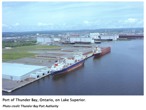
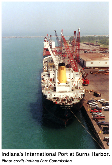
There are 15 major international ports and some 50 smaller, regional ports on the Great Lakes-St. Lawrence Seaway system. Some of the larger ports include the following:
- Indiana's International Port/Burns Harbor at Portage
- Port of Detroit (Michigan)
- Port of Duluth-Superior (Minnesota/Wisconsin)
- Port of Hamilton (Ontario)
- Port of Lorain (Ohio)
- Port of Milwaukee (Wisconsin)
- Port of Montreal (Québec)
- Port of Ogdensburg (New York)
- Port of Oswego (New York)
- Port of Québec
- Port of Sept-Iles (Québec)
- Port of Thunder Bay (Ontario)
- Port of Toledo (Ohio)
- Port of Toronto (Ontario)
- Valleyfield (Québec)
- Port Windsor (Ontario)
On the Great Lakes (and all U.S. waterways), cargo moving between ports is governed by the Jones Act. The Jones Act is one of several U.S. cabotagelaws, which reserve all forms of transportation to American companies employing American workers. The rules of the Jones Act also ensure that shipping on U.S. waters is governed by the world's highest safety and operational standards. The U.S. Coast Guard oversees every aspect of U.S.-Flag shipping on self-propelled vessels, including construction and ship maintenance, and qualifications of the crew.
Issues facing the shipping community
Navigation maintenance dredging: Dredging involves the periodic removal of accumulated sediments on the bottom of waterways, harbors and shipping channels. Commercial navigation could not successfully continue on the Great Lakes without dredging. A ship's draft is the depth of water needed to float a ship. A slight decrease in the depth of a waterway means that a vessel must decrease its draft (i.e., reduce the amount of cargo that its carrying). For example, a 1,000-foot vessel will lose 270 tons of cargo for each inch reduction in its draft!
What to do with dredged material is also a growing issue in the Great Lakes region. In-water disposal was common in the late 1960s but after a century of industrial activity and related pollution around port cities, some of the dredged material now contains highly contaminated sediments. Since dredgers don't want to return these polluted substances back to the lakes, confined disposal facilities (or CDFs) have been built. Also beneficial uses, such as beach nourishment, landscaping and road construction fill, are being explored for the non-polluted dredged material.
More about dredging and contaminated sediments
Ballast water management to prevent the spread of invasive species: Ballast is a heavy substance (in most cases water) used to improve the stability and control the draft of a ship. Research has shown that many of the non-native invasive species, like zebra mussels, that have invaded the Great Lakes have traveled in the ballast water tanks of ships. Since prevention is the key to blocking future introductions, ballast water management is now a priority of the shipping community. U.S. law and Canadian policy now requires an exchange of ballast water in the ocean before a vessel can enter the freshwater system. Other experimental techniques involve filtering, heating or chemically treating the ballast water to kill any unwanted critters that are looking to find a new home in the Great Lakes.
More about ballast water treatment
To the ocean and beyond
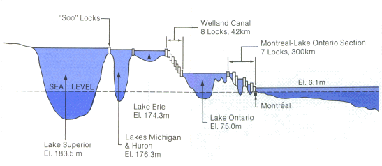
The Great Lakes and St. Lawrence River are part of a vast system linking North America's heartland with ports and markets throughout the world. The world's longest deep-draft inland waterway, the system extends from Duluth, Minn., on Lake Superior, to the Gulf of St. Lawrence on the Atlantic Ocean, a distance of more than 2,340 miles. This shortcut to the continent's interior was made possible with the construction of a ship canal and lock system opened in 1855 at Sault Ste. Marie, Mich., the development of the Welland Canal since 1829, and the completion of the St. Lawrence Seaway in 1959.
The Soo Locks
The world-famous Soo Locks form a passage for deep-draft ships around the rapids in the St. Marys River at the far east end of Lake Superior. Early pioneers arriving in the territory were forced to carry their canoes around the rapids. When settlement of the Northwest Territory brought increased trade and large boats, it became necessary to unload the boats, haul the cargoes around the rapids in wagons, and reload in other boats.
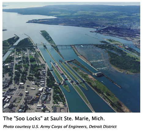
The U.S. Congress passed an act in 1852 granting 750,000 acres of public land to the state of Michigan as compensation to the company that would build a lock permitting waterborne commerce between Lake Superior and the other Great Lakes. The Fairbanks Scale Company, which had extensive mining interests in the Upper Peninsula, undertook this challenging construction project in 1853. Within a few years, commerce through the canal had grown to national importance, and the need for new locks became clear. The funds required exceeded the state's capabilities, and thus, in 1881 the locks were transferred to the U.S. government, and were placed under the jurisdiction of the U.S. Army Corps of Engineers. The Corps has operated the locks, toll free, since that time.
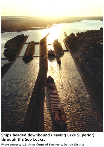
The locks are like a series of steps that the ships must make. These "steps" occur when a ship is placed in a lock chamber and water is released or added to the chamber to change its depth (i.e., elevation). With the ship safely floating within the lock chamber, the level of the water moves the ship up or down.
Currently there are four U.S. locks and one smaller Canadian lock. The largest lock, 1,200 feet long and 110 feet wide, was opened in 1969. This new large lock revolutionized lake transport because it could accommodate 1,000-foot vessels, carrying up to 60,000 tons. The shipping industry responded by building 30 new U.S.-flag vessels (including 13 thousand-footers) and lengthening 10 others.
Today, passages through the locks average about 10,000 vessels per year, varying in size from small passenger vessels and workboats to large bulk freighters. Another large lock is in the planning stages and could be built during the next decade if federal and state funding allows.
The St. Lawrence Seaway
The St. Lawrence Seaway extends from Montreal to Lake Erie and includes the Welland Canal. It is this series of locks, canals and channels that links the Atlantic Ocean and St. Lawrence River to Lake Ontario and the four upper Great Lakes. The Great Lakes-St. Lawrence Seaway system is jointly operated and maintained by The Saint Lawrence Seaway Development Corporation (United States) and The Great Lakes St. Lawrence Seaway System (Canadian). The seaway remains a model of binational cooperation between the two nations.
See also: Montreal/Lake Ontario section of the seaway
The Welland Canal
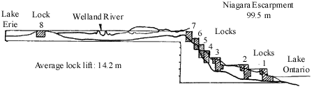
The Welland Canal, with its eight large locks, was built to allow ships to pass around Niagara Falls as they move from Lake Ontario to Lake Erie. This canal system, the western section of the St. Lawrence Seaway, ranks as one of the outstanding engineering feats of the 20th century. The current Welland Canal, the fourth to be constructed, was opened in 1932 and was the first segment of the modern seaway to be built. Vessels up to 740 feet (225.5 meters) long and 78 feet (23.8 meters) wide can travel through the locks. These ships may carry as much as 32,000 tons (29,000 tonnes) of iron ore or other cargo, and draft up to 26.3 feet (8 meters). With its long history, the Welland Canal is an integral part of the deep waterway that allows large lakers and ocean vessels to navigate to and from the heart of North America.