
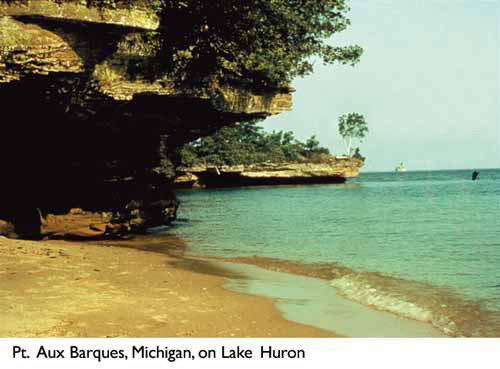
About a billion years ago, a fracture in the earth running from what is now Oklahoma to Lake Superior generated volcanic activity that almost split North America. Over a period of 20 million years, lava intermittently flowed from the fracture.
This geomorphic age created mountains covering the regions now known as northern Wisconsin and Minnesota, and the Laurentian mountains were formed in eastern Canada. Over time these mountains eroded, while occasional volcanic activity continued. Molten magma below the highlands of what is now Lake Superior spewed out to its sides, causing the highlands to sink and form a mammoth rock basin that would one day hold Lake Superior. Eventually the fracture stabilized and, over time, the rock tilted down from north to south.
The region went from fire to ice with the arrival of the glaciers, which advanced and retreated several times over the last 5 million years. During the periods of glaciation, giant sheets of ice flowed across the land, leveling mountains and carving out massive valleys. Where they encountered more resistant bedrock in the north, only the overlying layers were removed. To the south, the softer sandstones and shales were more affected. As the glaciers melted and began receding, their leading edges left behind high ridges, some of which can be seen today in the cliffs of Door County, Wisconsin, and the Bruce Peninsula in Ontario. Huge lakes formed between these ridges from the retreating ice fronts, and continually changed over time as the ice sheet moved northward.
Early drainage from these lakes flowed southward through the present Illinois River Valley toward the Mississippi River, through the Trent River Valley between present lakes Huron and Erie and through the Lake Nippissing-Ottawa River Valley from Georgian Bay on Lake Huron downstream to the present Montreal, Quebec, area.
Without the immense weight of the glaciers-thousands of feet thick in places- the land began to rebound. Even today, virtually all of the land in the Great Lakes basin continues to rise. Southern parts of the basin are rising slightly, less than 3 inches per century. The northeastern corner of the Lake Superior basin, however, is rebounding in excess of 21 inches per century.
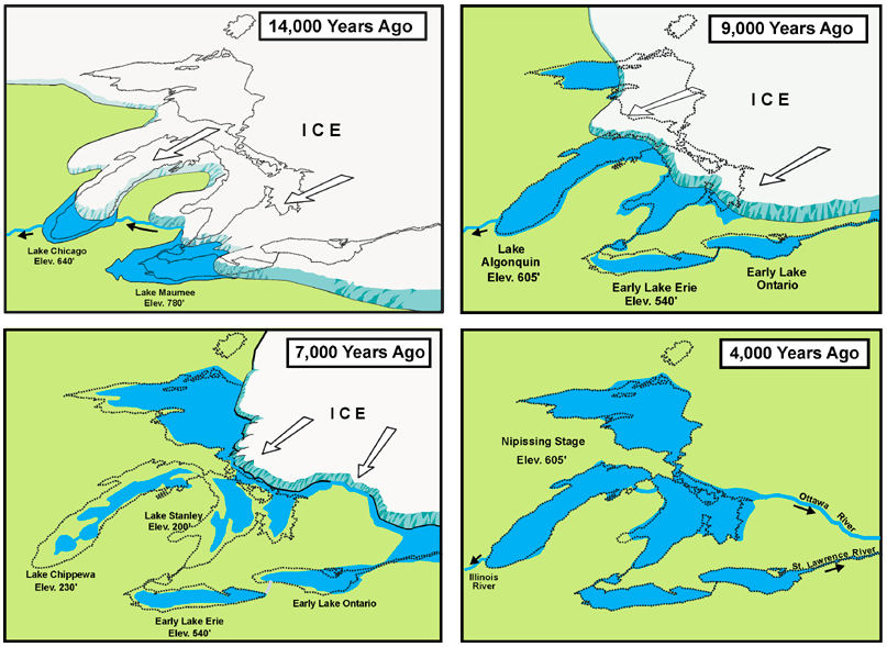
Since the retreat of the glaciers, water levels continued to undergo dramatic fluctuations, some in the magnitude of hundreds of feet. These extremes were caused by changing climates, crustal rebound and natural opening and closing of outlet channels. Within the last 1,000 years, evidence suggests that lake levels exceeded the range of levels recorded since 1865 by an additional five feet on lakes Michigan and Huron. As a consequence of these recent fluctuations, shoreline position and environments have dramatically changed. Dunes, baymouth barriers, embaymentsand river mouths have all been modified by the forces of water. Many dune formations-some hundreds of feet thick-were established during glacial periods. The tops of these dunes have been continuously sculpted by winds to form the majestic structures now visible.
Today, rebounding of the earth's crust, erosion, and changes in climate continue to alter the shapes and sizes of the Great Lakes. As one of the youngest natural features on the North American continent, the lakes remain a dynamic, evolving system.
Four of the five Great Lakes are at different elevations, leading like a series of steps toward the Atlantic Ocean. The five individual lakes are connected to each other through channelways, forming one system. Water continually flows from the headwaters of the Lake Superior basin through the remainder of the system.
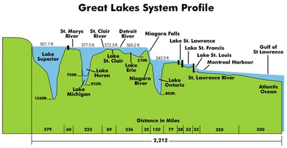
The St. Marys River is a 60-mile waterway flowing from Lake Superior down to Lake Huron, descending more than 20 feet in elevation. Lakes Michigan and Huron are connected by the deep Straits of Mackinac and are considered to be one lake hydraulically with lake levels rising and falling together. The St. Clair and Detroit rivers, and Lake St. Clair between them, form an 89-mile-long channel connecting Lake Huron with Lake Erie. The fall between Lake Huron and Lake Erie is only about 8 feet. The 35-mile Niagara River links lakes Erie and Ontario, with the majority of the 325-foot difference in elevation occurring at Niagara Falls. The man-made Welland Canal also links the two lakes, providing a detour around Niagara Falls. From Lake Ontario, water flows into the St. Lawrence River, which converges with the Ottawa River near Montreal to flow to the Atlantic Ocean.